
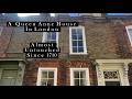
Another shift in building styles takes place further down the road. Most of the housing developed by the Haberdashers company in the late 19th century follows a uniform style (albeit with variations in size). After 105 Drakefell, different styles appear. This is because the boundary of the land owned by the Haberdashers at this time is next to this house – so 105 (called ‘The Anchorage’) and 170 on the opposite side of the road mark the eastern limit of the Haberdashers estate. Both have small Haberdashers' plaque on their walls. Next to 105, the fine ‘owl house’ (107-9) is completely different (OK it's not actually called the owl house but I call it that on account of it having an owl above the entrance).
 Aspinall Road is a short cul de sac off Drakefell Road leading to the footbridge over the railway line. There are some good views down the line to Battersea Power station in the west and St Peter's Church (Wickham Road) in the east, albeit somewhat obscured by the cage over the bridge.
Presumably the cage is to prevent vandalism, although it does seem a bit odd as just down the line there is another road bridge with no protection at all.
Perhaps it might also discourage casual train robbers, if they still exist. On the other side of the railway bridge Aspinall Road continues. During the 1970s, great train robber Robert Welch lived on this road after being released at the end of a 12 year stretch for his part in the famous 1963 heist (Times, 19.12. 1979).
The bottom end of Drakefell Road is marked as SE14, even though further up Telegraph Hill and further away from Brockley Cross it is SE4. On the corner of Drakefell and Endwell Road is one of my favourite local sights at the moment. A garden fence has come down exposing a 1m vertical slice of the built up garden, so you can see what lies under the surface –a mixture of soil, roots and old bottles.

It's like an archaeologist’s trench. Just around the corner off Endwell Road is the Brockley Cross Business Centre, where one of the country's leading archaeological contractors is actually based - Pre-Construct Archaeology. PCA recently excavated the Bermondsey Abbey site and have worked on a number of sites across Lewisham.
Childnet International also have their offices in the Business Centre.
Endwell Road heads down to the notorious double roundabout at the cross, passing the (soon to be completed?) Tea Factory development. Another building site is visible down Mantle Street on the site of the recently demolished Maypole pub. I don’t think the pub itself is particularly missed but the name is.
I have heard the theory put forward that there was a maypole here on the old village green at Brockley, maybe even that the name Endwell Road suggests that there was a well there too. Speculation maybe, interested whether any old maps confirm or disprove this.
 At 93 Endwell Road there is a vacant shop above which can be seen the sign for its sometime use – ‘baker, confectioner, patisserie, chocolatier, caterer’. Yum, shame it's not there anymore.
Turning from Brockley Cross into Shardeloes Road we are once again in SE14. After the timber yard one of the first buildings on the left is the pentecostal Calvary Church of God in Christ, an uninspiring brick hall but with a fine pair of palm trees flanking its crucifix. Well it is Good Friday today.

After the junction with Vesta Road the housing builds up with council blocks on both sides. The names - Yew house, Cherry Tree House, Birch House – suggest more greenery than is in evidence, though there are some fine birch trees outside Alban House.
At the junction of Shardeloes Road and Lewisham Way there is the entrance to a modern gated cul-de-sac, Chestnut Way, on one side and on the opposite corner the grand Surrey House, now a Goldsmiths College building. It has a name plaque on the wall that suggests it was orginallly called Bryn-Towy.
 St Donatts Road, heading back down towards Shardeloes from Lewisham Way, starts with The Rosemary Branch pub on the corner. Most of the housing is Victorian terracing (a plaque on one row reads ‘Bermuda Villas 1866’) but there an interesting exception at no. 75a with a modern brick/wooden house called The Ark squeezed into a narrow space.
St Donatts does extend for a short distance beyond Shardeloes down to Clare Road. This section is Council housing plus the Little Gems Day Nursery. There also seems to be a graveyard for shopping trolleys.
Barriedale and Millmark Grove stretch round in a crescent parallel to Shardeloes Road. Unlike most of the dark brick housing in this area, the interwar terracing in these streets is mostly white with each road having a distinct appearance (Barriedale is the first picture below, Millmark Grove the second, note the timbers which distinguish the houses in the latter).
Incidentally, the early nineteenth century Croydon canal ran along the line of Shardeloes Road and Barriedale.


3 comments:
What a good project. I am enjoying reading it. I just wanted to say that the reason that stretch of Shardeloes Rd is so strange is exactly because it is the filled in Croydon Canal you refer to at the end - the back gardens of the houses ran down to the canal.
Robert welch the great train robbery still lives there to this day!!!
Have only just discovered this. Thank you. Moved to Greenwich SE10 on 14 December after living in North West London since I came to the Capital in 1963! Love the area and walk out every day to find out more. Want to join the Lewisham History Society for more information and buy any books and publications on the subject. I can find none in the shops.
Was wondering how Shardeloes Road got it's name. Wonder if it is named after a magnificent house of the same name in Buckinghamshire twixt Denham and Beaconsfield. A huge white mansion set in isolation and visible sometimes from the A40. I worked for a Beaconsfield estate agent for a couple of years before I ran away to London and Shardeloes was always coming up. I never got to see it close to and have often since tried to find the road I would need to take to get up to it.
Anyway, if anyone knows the origin I would be glad. I am a Blue Badge London Tour Guide and for the last 25 years have been taking groups on walks in every single London Borough. I have scores of books on London and even though I had a huge cull when I moved south and downsized, I can't resist buying more. Just purchased 4 on Greenwich but as I say, cannot find any on Lewisham. Have not found a book shop of quality actually, apart from Waterstones near the Cutty Sark and a bookshop in Blackheath where 2 years back I found some lovely Blackheath books.
Post a Comment